São Lourenço - Madeira


Hiking Technical Sheet
- Average Duration: 2h30
![plage seixal sable noir]()
- Distance: 4.0 + 4.0 km
![plage seixal sable noir]()
- Elevation Gain:
![plage seixal sable noir]()
- Elevation Loss:
![plage seixal sable noir]()
- Highest Point: 77 m
![plage seixal sable noir]()
- Lowest Point: 5 m
![plage seixal sable noir]()
- Difficulty: Medium
![plage seixal sable noir]()
- Return to Starting Point:
![plage seixal sable noir]()
- Municipality: Caniçal
![plage seixal sable noir]()


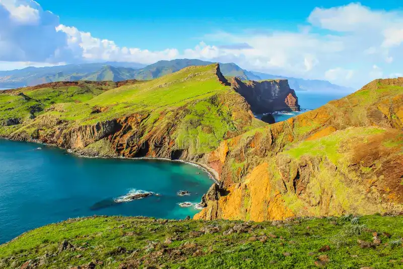
São Lourenço, also known as Ponta de São Lourenço, is a peninsula located at the eastern end of the island of Madeira, Portugal. It is one of the main natural attractions of the island and a site of exceptional beauty. Here is some information about São Lourenço:
1. Geography: São Lourenço is a volcanic peninsula that stretches for about 9 kilometers along the eastern coast of Madeira. It is characterized by steep rock formations, imposing cliffs, deep ravines, and arid landscapes. The region is primarily composed of basalt, a black volcanic rock, creating a striking contrast with the rest of the island.

2. São Lourenço Hikes:São Lourenço is a paradise for hikers and nature lovers. There is a marked trail that runs along the peninsula, offering spectacular views of the sea and cliffs. Hiking in São Lourenço is a unique experience, with wild and preserved landscapes that change as you progress along the trail.
3. Points of Interest:During the hike in São Lourenço, you can admire points of interest such as Baía d'Abra, a picturesque cove with fascinating rock formations, and Miradouro da Ponta da Furada, a viewpoint that provides panoramic views of the Atlantic Ocean. You can also observe the specific flora and fauna of the region throughout the journey.


4. Conservation:São Lourenço is classified as a nature reserve, which means it is protected and preserved due to its ecological importance and natural beauty. It is essential to respect the rules and regulations in the area to preserve its fragile ecosystem.

São Lourenço is a must-visit for nature enthusiasts and those seeking breathtaking scenery during a trip to Madeira. Whether for a hike or simply to enjoy the panoramic view, this peninsula offers a unique and memorable experience to island visitors.
Where to Eat in São Lourenço?
There is a snack stand in the middle of the hike, but it closes early, and occasionally there are sandwich trucks in the São Lourenço parking area. However, you can find dining options nearby, especially in the towns and villages surrounding Madeira. For example, the town of Caniçal, located a few kilometers west of São Lourenço, offers several restaurants and cafes where you can dine.
History of São Lourenço
The history of São Lourenço, or Ponta de São Lourenço, dates back millions of years when volcanic activity shaped the island of Madeira. Here is an overview of the history of this unique region:
Geological Formation:São Lourenço is a volcanic-origin peninsula located at the eastern end of the island of Madeira. It is mainly composed of basalt, a volcanic rock formed by solidified lava flows. Over time, erosion has carved impressive cliffs, deep gorges, and spectacular rock formations along the coast.
Human Colonization:The first settlers of Madeira settled near the coast, attracted by abundant marine resources. However, due to the challenging topography and arid conditions of São Lourenço, there was never permanent colonization in this region.
Conservation:Due to its unique biodiversity and ecological significance, São Lourenço was designated as a nature reserve in 1982.
Today, São Lourenço is a cherished destination for nature lovers and hikers. Visitors can explore the marked trails that traverse the peninsula and enjoy the spectacular landscapes offered by this pristine region. It is a fascinating place to discover during a visit to Madeira.